


地質学会とは
ログイン
MAIN MENU
An Engagement with Japan…and Volcanoes, Iron, and Phytoplankton in the Southern Ocean
2018年度日本地質学会国際賞
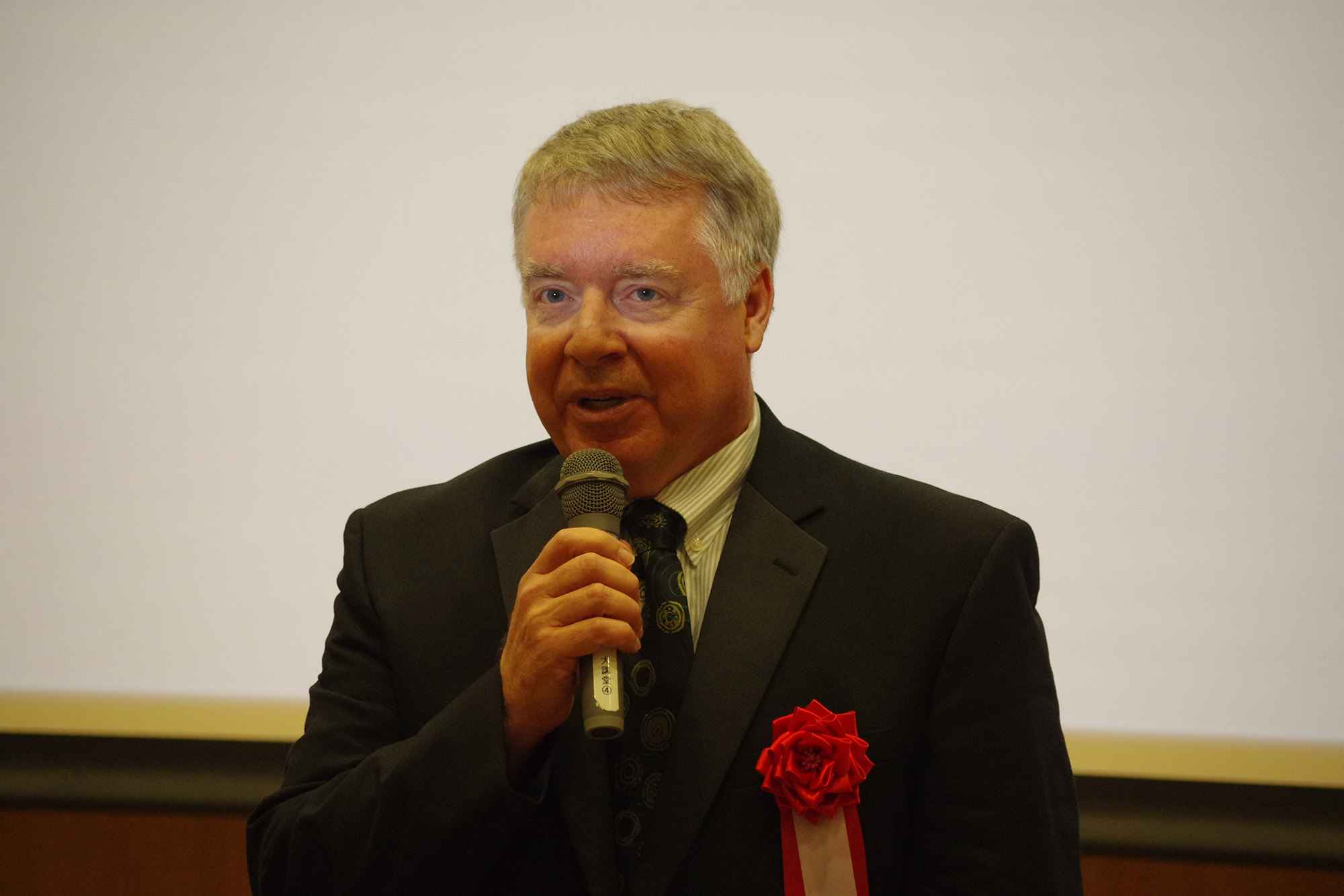
Prof. Millard (Mike) F. COFFIN (Institute for Marine and Antarctic Studies, University of Tasmania, Australia; School of Earth and Climate Sciences, University of Maine, USA; Woods Hole Oceanographic Institution, USA)
 I am deeply honored to have been awarded the 2018 International Prize of the Geological Society of Japan in recognition of my contributions to the field of research on Large Igneous Provinces (LIPs), implications for their formation process, and impact on global environments. I truly appreciate the recognition by the Society, and sincerely value my long and rewarding relationships with Japanese colleagues and friends.
This contribution consists of two parts, the first a description of my engagement with Japan, and the second a summary of my recent work on Earth-Ocean-Biosphere interactions in the Southern Ocean surrounding Antarctica.
A Synopsis of My Engagement with Japan
My fascination with Japan long preceded my engagement with Japanese scientists. Japan first piqued my interest when I was a high school student in the early 1970s. A Japanese film festival held at the University of Maine, near my hometown of Bangor, Maine, USA, intrigued me, and I attended every film showing that I could, including Seven Samurai, Woman in the Dunes, Yojimbo, Rashomon, and Ugetsu Monogatari. These and other Japanese films inspired a curiosity that spurred me to further study and engagement. As a first-year undergraduate at Dartmouth College, I commenced formal study of Japan (and China) by taking a course in East Asian history, which opened my eyes to the long and captivating sweep of Japanese history. Also while at Dartmouth (1974-1978), I began tutoring Japanese and other international students in English, an activity I continued during my graduate studies at Columbia University in the City of New York (1978-1985). Such personal interactions with Japanese natives complemented my nascent knowledge and growing curiosity about the country.
Significantly, while a graduate student, I made my first visit to Japan (Tokyo) in 1980, marveling at the people, culture, and country first-hand. It was a brief visit, as I was en route from New York to Guam to board a month-long research voyage to the Shatsky Rise aboard RV Vema. It would be another 12 years before my second visit to Japan, but in that interval I gained my first extended exposure to and a deep appreciation for Japanese cuisine, specifically at the Japanese restaurant Asakusa in Canberra, Australia, where I worked from 1985 through 1989 at Geoscience Australia. Asakusa was staffed largely by spouses of diplomatic staff at the Embassy of Japan in Canberra, lending an atmosphere of authenticity and refinement to the restaurant absent in the vast majority of Japanese restaurants outside of Japan today.
My engagement with Japanese scientists commenced in 1992 on my second visit to Japan, when I attended the 29th International Geological Congress (IGC) in Kyoto. Prof Asahiko TAIRA, then at the University of Tokyo, had organized a session on scientific ocean drilling to which I contributed. That session launched a working relationship and close friendship with Prof TAIRA that continues to the present day. Scientific ocean drilling has proven to be the catalyst for many more interactions with Japanese scientists. I had moved from Australia to the University of Texas at Austin in 1990, and serving as a US member of the Joint Oceanographic Institutions for Deep Earth Sampling (JOIDES) Planning Committee (PCOM), I made my third visit to Japan (Makuhari) in 1995 to participate in a PCOM meeting. At this meeting I became acquainted with Profs Kyoshi SUYEHIRO and Kensaku TAMAKI, both then at the University of Tokyo, who became colleagues and friends. Such developing relationships with Japanese scientists in the early 1990s led to a joint Japanese-American, month-long research voyage to study the collision of the Ontong Java Plateau and the Solomon Islands aboard RV Maurice Ewing in 1995, during which I got to know Prof SUYEHIRO much better. Following this voyage, Prof TAIRA and I began planning a joint Japanese-American, month-long research voyage to study the Ontong Java Plateau that we undertook aboard RV Hakuho Maru in 1998.
Japan’s decision in the 1990s to construct the riser drilling vessel Chikyu and ultimately to co-lead the next decade (2003-2013) of scientific ocean drilling with the US led to the 1997 Conference on Cooperative Ocean Riser Drilling (CONCORD) in Tokyo, which further cemented my ties with Japanese scientists. This was the first of three major planning meetings held by Japan, the US, and Europe, respectively, for what became the Integrated Ocean Drilling Program (IODP; 2003-2013). The second meeting, the Conference on Multiple Platform Exploration of the Ocean (COMPLEX), was held in 1999 in Vancouver, and shortly thereafter I was enlisted to Co-Chair (with Judy McKenzie of ETH-Zürich) the international, 11-member, IODP Planning Sub-Committee Scientific Planning Working Group charged with developing the initial science plan for the IODP. On that Committee, I worked closely with Profs SUYEHIRO, who had moved to the Japan Agency for Marine-Earth Science and Technology (JAMSTEC), and Yoshiyuki TATSUMI, then at the University of Kyoto. The third and final planning meeting, the Alternative Platforms as Part of the Integrated Ocean Drilling Program Conference (APLACON) was convened in Lisbon in 2001. The IODP Initial Science Plan – Earth, Oceans, and Life – incorporated input from all three planning meetings and was published in 2001.
Just before the turn of the millennium, I received a fateful, entirely unforeseen telephone call and query from Prof TAIRA: a full professorship at the University of Tokyo’s Ocean Research Institute (ORI, now Atmosphere and Ocean Research Institute, or AORI) would become open soon, and would I be interested in applying? During 2000, I contemplated this extraordinary opportunity – as well as offers of positions in Washington, DC, USA, and Sydney, Australia – and late in the year discussed it further with Profs TAIRA, TAMAKI, and SUYEHIRO face-to-face at a University of Tokyo-JAMSTEC seismic workshop in Tokyo. In 2001, I visited Tokyo twice, investigating and interviewing for the professorship, before becoming the first non-Japanese tenured full professor in ORI’s 39-year history that boreal autumn.
As a professor at ORI from September 2001 through December 2007, I conducted an active, proposal-driven seagoing research program; taught and supervised PhD and Masters students; and established the ORI Seismic Research Center. I led or participated in six research voyages (Macquarie Ridge Complex, Hawaii, Manihiki Plateau, Ontong Java Plateau, Naturaliste Plateau), including serving as the first non-Japanese Chief Scientist aboard RV Hakuho Maru and RV Kairei, and dove to 4000+ m in Shinkai 6500. Peer-reviewed publications with Japanese co-authors currently total 21. Also during my professorship at ORI, I worked as a Senior Researcher at JAMSTEC (2002-2003), as a consultant for the Sumitomo Ocean Development & Engineering Company (2003-2005), and as a consultant for the Ministry of Foreign Affairs (2006-2007). The last involved working on Japan’s Extended Continental Shelf submission to the United Nations (UN) Commission on the Limits of the Continental Shelf under the UN Convention on the Law of the Sea.
As co-leaders of the IODP, Japan and the US agreed to alternate leadership every two years. A coin toss decided whether Japan or the US would lead the first two years of the IODP (2003-2005), and Japan won the toss. That resulted in Prof TAMAKI chairing the IODP Science Planning and Policy Oversight Committee (SPPOC), and myself chairing the IODP Science Planning Committee (SPC). Co-leadership necessitated substantial governance, management, administrative, cultural, and other changes – to which I devoted considerable effort – following the US having led international scientific ocean drilling (Deep Sea Drilling Project and Ocean Drilling Program) for the previous 35 years. Over the first two years of IODP, I headed the IODP Science Advisory Structure consisting of ~150 scientists from the ~25 IODP member countries serving on seven committees, panels, and program planning groups (PPGs). During that time, I represented Japan at 47 IODP-related meetings, 14 in Japan and 33 elsewhere in Asia, Europe, and North America. This involved flying ~575,000 km in those two years.
Although I departed Japan at the end of 2007 to become the inaugural Director of Research at the United Kingdom’s National Oceanography Centre in Southampton, I have maintained close ties with the Japanese community through cooperative research projects and scientific ocean drilling. In 2010, I was part of the shipboard scientific party aboard RV Kairei to investigate the crustal structure of the Ontong Java Plateau. Following my move back to Australia in 2011 to become the inaugural Executive Director of the new Institute for Marine and Antarctic Studies at the University of Tasmania, I chaired the Chikyu+10 IODP Workshop held in Tokyo in 2013. In 2014, I served as a member of the External Review Committee of the University of Tokyo’s Atmosphere and Ocean Research Institute (AORI), and since 2017 I have served as a member of the JAMSTEC Advisory Board. My rewarding and fulfilling engagement with Japan continues!
Volcanoes, Iron, and Phytoplankton in the Southern Ocean
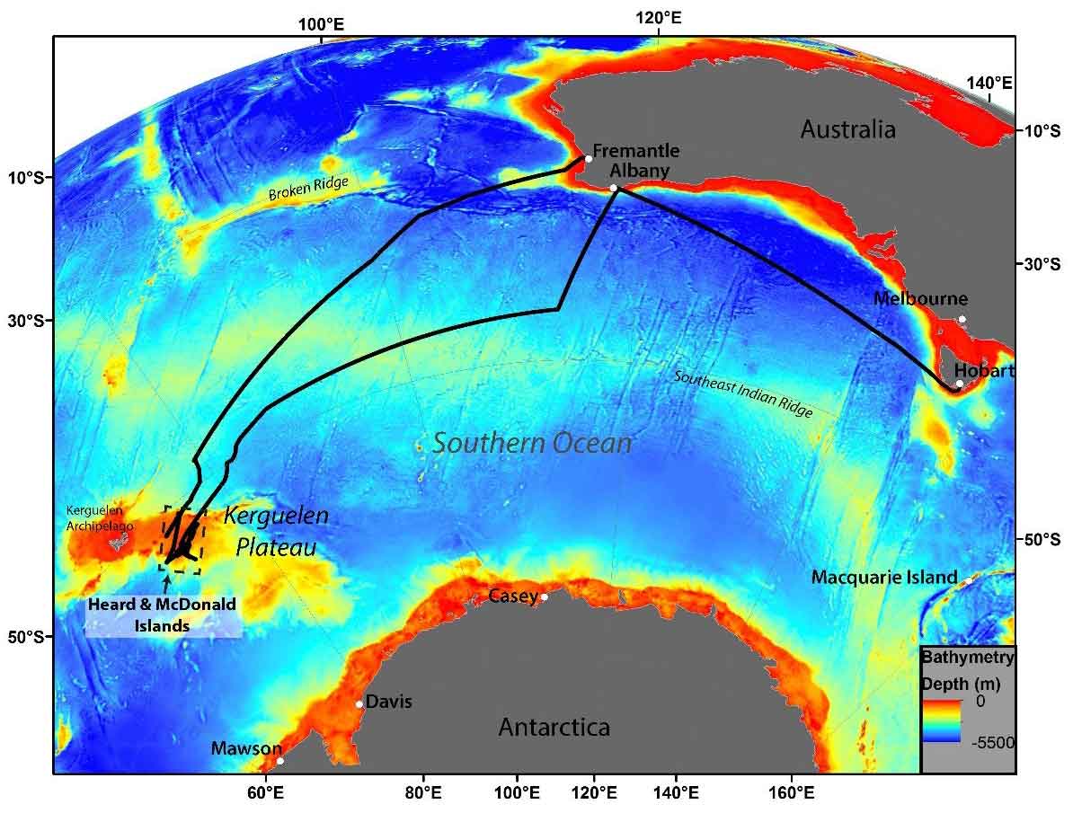
The first maximum endurance research voyage of Australia’s new Marine National Facility, the research vessel (RV) Investigator, sailed deep into the southern Indian Ocean in early 2016 (Fig. 1_http://mnf.csiro.au/~/media/Files/.....), and I had the privelege of serving as Chief Scientist. The purpose of the voyage was to test the hypothesis that hydrothermal activity driven by active submarine volcanoes in the Southern Ocean fertilises surface waters with iron, thereby enhancing biological productivity beginning with phytoplankton. Phytoplankton are important because they supply half of the oxygen in Earth’s atmosphere; their growth is limited by iron supply in the anemic Southern Ocean as well as elsewhere in the global ocean. To test the hypothesis, the shipboard scientific party included geoscientists to identify and characterize active submarine volcanoes, biogeochemists to analyze water samples for iron and other trace elements, physical oceanographers to characterize ocean circulation in the study region, and marine biologists and ecologists to examine primary productivity in the study area. Shore-based researchers have augmented the shipboard scientific party.
 |
 |
| Fig. 1. Track map of RV Investigator voyage IN2016_V01 to the Heard and McDonald Islands (HIMI) region. *You can see the big picture when you click the image |
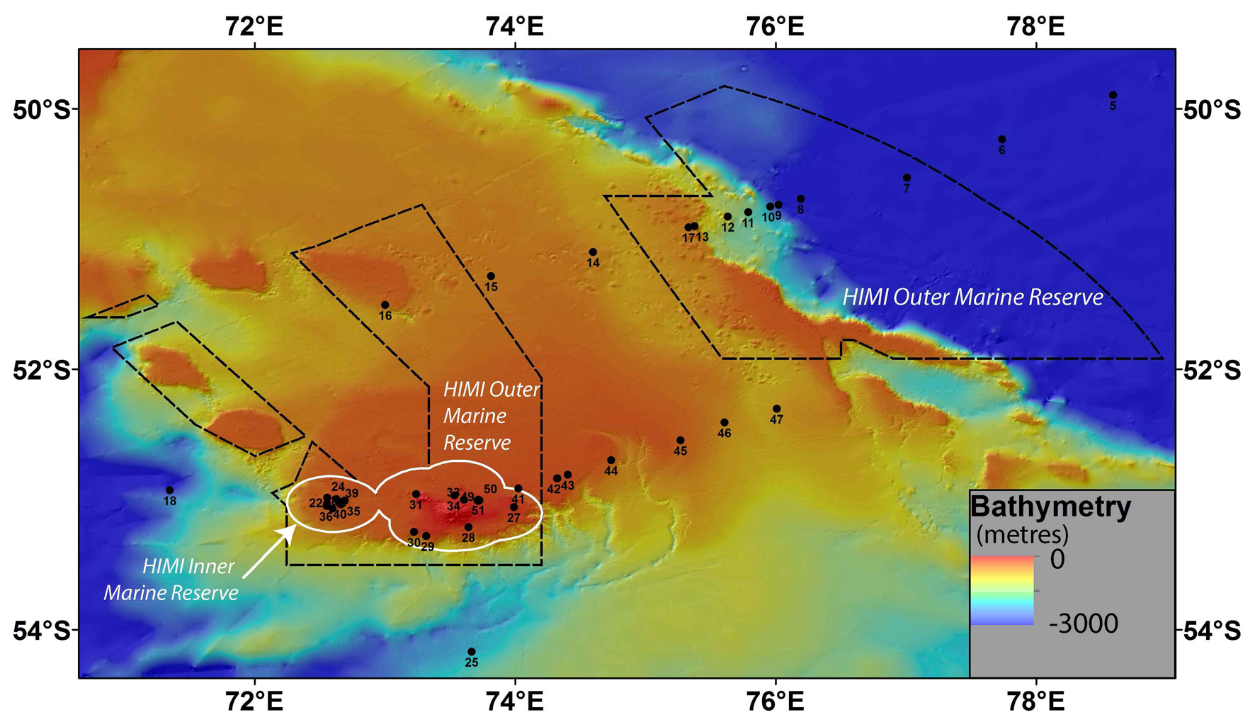
Fig. 2. RV Investigator IN2016_V01 stations on the central Kerguelen Plateau. McDonald (west) and Heard (east) islands lie inside the HIMI Inner Marine Reserve . |
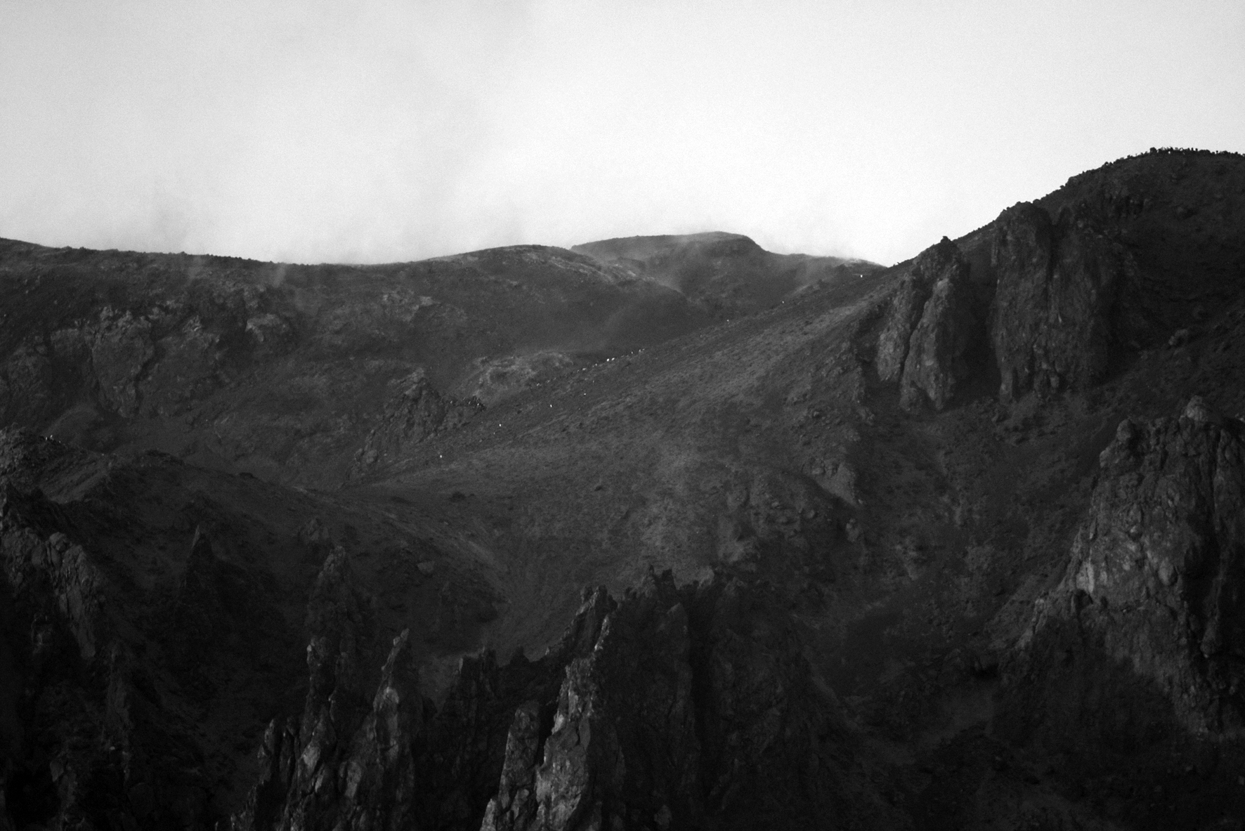
Australia’s only active volcanoes, Heard and McDonald islands (HIMI) on the Kerguelen Plateau, are among the world’s most active hotspot volcanoes. Located at ~53°S approximately 4000 km from the closest ports, Fremantle, Australia (Fig. 1), and Cape Town, South Africa, the islands are rarely visited and lack any ongoing monitoring or occupation. HIMI were inscribed on the United Nations Educational, Scientific, and Cultural Organization (UNESCO) World Heritage List in 1997 (https://whc.unesco.org/en/list/577). They constitute the only sub-Antarctic island group that has an intact ecosystem, to which no known species has been introduced directly by humans, and where the ongoing evolution of plants and animals occurs in a natural state.
Heard Island encompasss 368 km2 and reaches a maximum reported elevation of 2745 m; the McDonald Islands are much smaller, covering 2.5 km2 and attaining a maximum reported elevation of 186 m (n.b., both elevations are less than what observations during our voyage suggest). HIMI’s volcanic activity is only recorded infrequently by satellites during brief breaks in persistent cloud cover or by observations from sporadic transiting ships. Satellite observations of ocean color show extensive blooms of phytoplankton on the Kerguelen Plateau (e.g. Bowie et al, 2015), and legacy narrow-beam echosounding data (Beaman & O’Brien, 2011) indicate many features on the Kerguelen Plateau resembling volcanic edifices, some of which are quite young (Duncan et al, 2016).
The state-of-the-art RV Investigator (http://mnf.csiro.au/Vessel/Investigator-2014.aspx), built in Singapore, was delivered to its homeport of Hobart, Tasmania, Australia in September 2014, and subsequently underwent approximately a year of trials. With a Det Norske Veritas (DNV) Silent-R classification, the 94-m, 5,893-ton (maximum displacement) ship is ideal for acoustic work from its multibeam seafloor mapping systems (Kongsberg EM122 and EM710), sub-bottom profiling system (Kongsberg SBP120), and water column echosounders (Kongsberg/Simrad EK60 and ME70) that were critical for our research program. Other key instruments for our research aboard the multi-purpose vessel were trace metal rosettes (TMRs), conductivity-temperature-depth (CTD) rosettes, in situ pumps (ISPs), a bio-optical sensor package, a deep-tow camera system, a Triaxus remotely operated towed vehicle, drifters, floats, Smith McIntyre sediment grabs, and rock dredges. Our voyage carried a full complement of 40 researchers, students, and support staff, and 20 ship’s crew.
The research voyage may be divided into three distinct components: seafloor hydrothermal system prospecting, sensing/sampling, and imaging; plateau water column transects with reference sites; and transits. During all three components, we acquired data from the multibeam systems, multi-frequency split-beam echosounders, sub-bottom profiler, gravimeter, thermosalinograph, aerosol sampling, air chemistry sampling, underway seawater analyses, expendable bathythermographs (XBTs), atmospheric underway sensors, and biological oceanography underway sensors. We also launched robotic floats for the Australian office (http://imos.org.au/facilities/argo/) of the International ARGO Program (http://www.argo.net/), the Southern Ocean Carbon and Climate Observations and Modeling (SOCCOM) project (https://soccom.princeton.edu/), and the Australia-India Strategic Research program (https://www.science.gov.au/international/CollaborativeOpportunities/AISRF/Pages/default.aspx), and drifters for the US National Oceanic and Atmospheric Administration’s (NOAA) Global Drifter Program (http://www.aoml.noaa.gov/phod/gdp/index.php). The first two components comprised the core of our scientific investigations, and they intermingled during the 26 days that we were able to devote to work over the Kerguelen Plateau. Transits, including equipment testing and a medical evacuation diversion from a great circle route, consumed 24 days.
We undertook most of our work within sight of HIMI (Fig. 2). Overall, we mapped 3,697.1 km2 of seafloor within the HIMI Marine Reserve Inner Marine Zone, or ~22% of its total area, which comprise the first multibeam bathymetry data to be acquired in this region. Water depth averages ~200 m within the Zone, with a maximum depth of ~1100 m. In the Zone, we mapped 56 previously unknown sea knolls around the McDonald Islands, and three around Heard Island. Eight dredges, including six from the newly discovered sea knolls, recovered volcanic rock for petrological, geochemical, and 40Ar/39Ar dating analyses, and eight Smith McIntyre grabs recovered sediment from around the islands for geochemical analyses.
Water column biogeochemical sampling included 50 successful CTDs, 40 TMRs, and 11 in situ pump deployments (Fig. 2). The CTDs yielded essential information on water column structure and provide water samples for 3He/4He analyses, an important proxy for hydrothermal activity, as well as for biological and microbiological analyses. Water samples from the TMRs provided critical information on dissolved iron, other trace metals, and other nutrients (N, Si, P, etc) in the water column. Particulate iron was captured by the in situ pumps.
Accompanying each CTD cast was a lowered acoustic Doppler current profiler (LADCP), which produced information on upper ocean currents. Complementing these casts were data from the shipboard ADCP. During the three phases of the voyage we deployed a total of 20 NOAA drifters to collect measurements of surface ocean currents, sea surface temperatures, and atmospheric pressure at sea level. For water column profiling, we deployed five ARGO floats for temperature and salinity data; three SOCCOM floats for dissolved oxygen, nitrate, and pH data; and two Bio-ARGO floats for dissolved oxygen, dissolved organic matter, nitrate, chlorophyll, and particle scattering data.
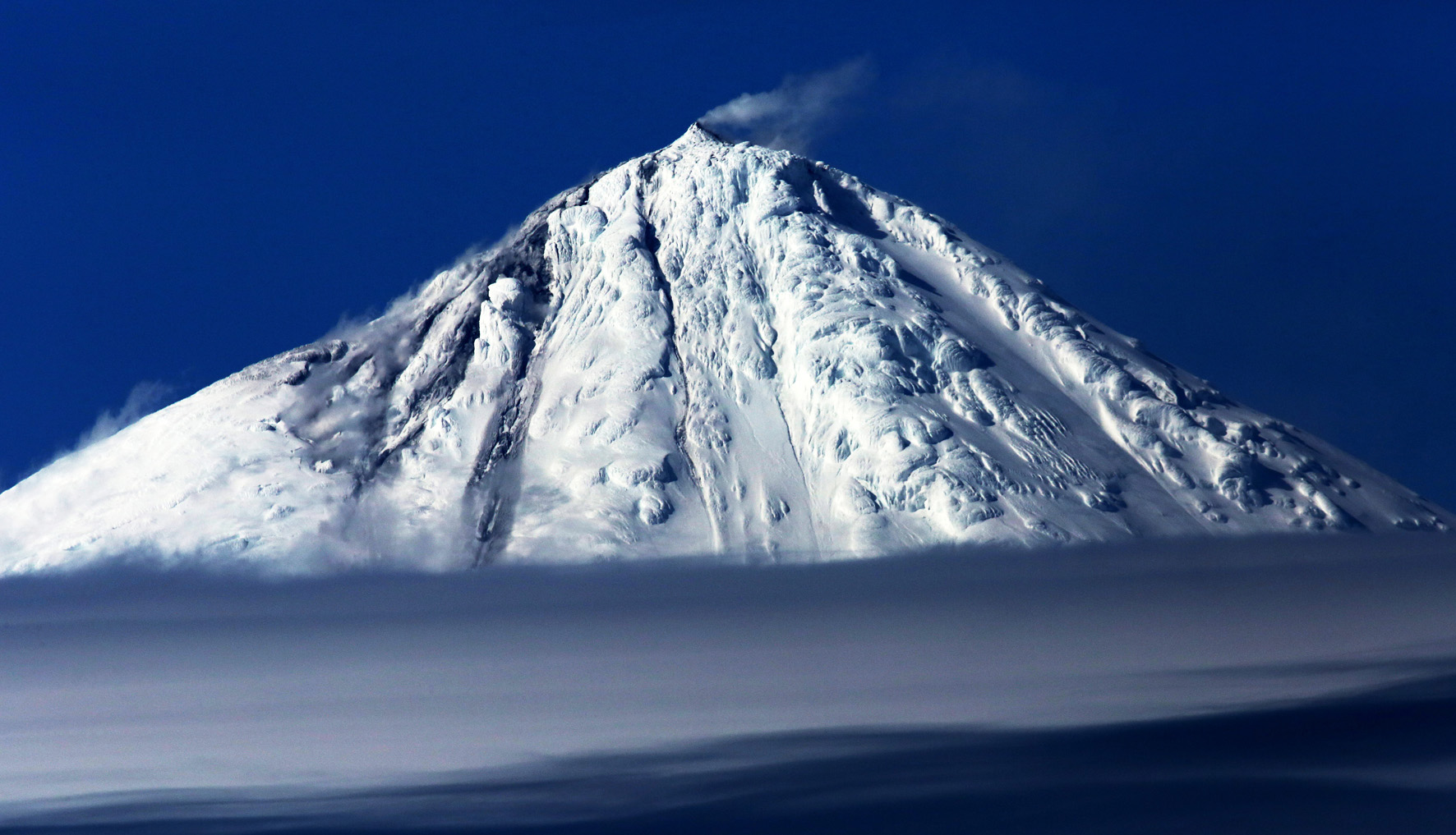
Observations of HIMI from the ship documented their active volcanism and hydrothermalism. Mawson Peak atop the Big Ben volcano on Heard Island appeared to be erupting continuously during the two weeks we worked around the island (Fig. 3). Whenever visible, the summit was emitting vapor, and lava was flowing down the flanks of Mawson Peak and Big Ben over glacial ice, generating steam. Fumaroles on the flanks of the McDonald Islands were also emanating steam (Fig. 4).
 |
 |
| Fig. 3. Eruption from Mawson Peak, Big Ben volcano, Heard Island. Note vapor emission from Mawson Peak, and lava flowing over glacier and generating vapor (left). | Fig. 4. Fumaroles on the McDonald Islands. |
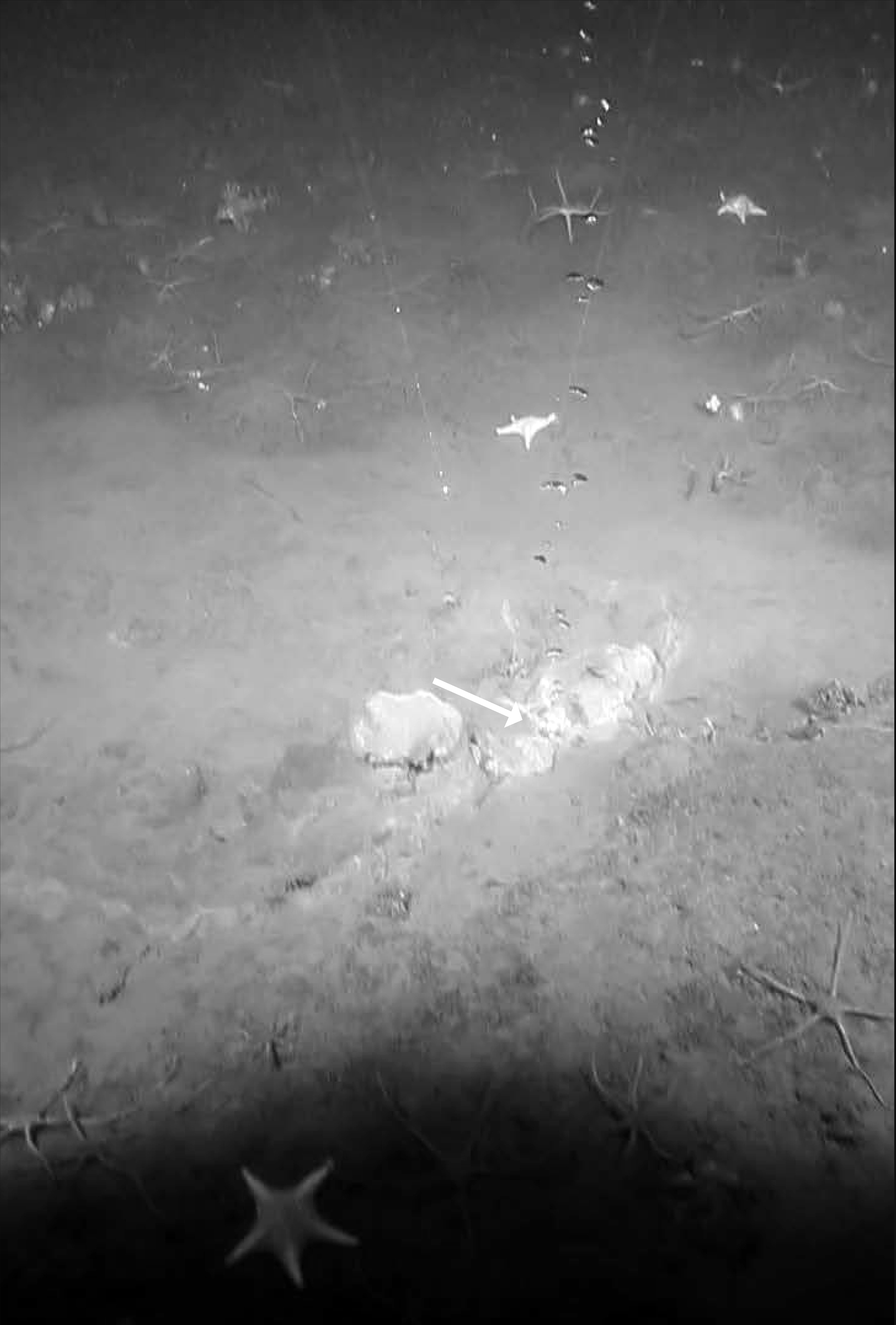
Active volcanism and hydrothermalism on HIMI suggested that similar phenomena might be occuring on the seafloor surrounding the islands. The first indication of such seafloor activity came as soon as we arrived at the Kerguelen Plateau with observations in the split-beam echolsounder data of acoustic flares originating from the seafloor (Fig. 5). Over the ensuing course of our work around HIMI, water column acoustic data revealed several hundred flares, typically in water depths . We are combining analyses of split-beam echosounder data, deep-tow camera footage (with co-mounted conductivity-temperature probe data), water-column 3He/4He data, sub-bottom profiler data, and sediment geochemistry to determine the cause of the flares (Spain et al, submitted). In the entire Southern Hemisphere, the only other documented occurrence of acoustic flares is offshore South Georgia Island, where the flares are caused by methane bubbles being emitted from the seafloor at cold seeps (Römer et al, 2014).
Following the identification of numerous acoustic flares in our split-beam echosounder data, we deployed the deep-tow camera to investigate their cause. North of Heard Island, we were able to obtain photographs and video footage of multiple sites where bubbles were emanating from the seafloor (Fig. 6) that coincided with the locations of acoustic flares observed in the echosounder data. Extremely turbid water around the McDonald Islands severely limited visibility, and we were compelled to abandon efforts to obtain deep-tow camera efforts after only a few runs across acoustic flare locations that did not image any of their potential causes.
 |
 |
| Fig. 5. Acoustic flare observed near the McDonald Islands |
Fig. 6. Bubbles emanating from the seafloor near Heard Island. Laser dots are 10 cm apart. |
Although HIMI are isolated from continental landmasses, the Kerguelen Plateau crust that they surmount is 20-25 km thick (Charvis et al, 1995), so the crustal setting of these hotspot volcanoes more closely resembles that of intraplate hotspot volcanoes on the continents (e.g., Yellowstone) than that of volcanoes along divergent plate boundaries (i.e., mid-ocean ridge volcanism). Furthermore, water depths averaging ~200 m around HIMI are much more similar to those of the 350 km2 Yellowstone Lake, with an average depth of 42 m (Sohn et al, 2017). Hydrothermalism associated with HIMI may be as extensive and diffuse as that of Yellowstone, which encompasses approximately 104 thermal features, including geysers, hot springs, mud pots, and fumaroles. Comparative volcanological and hydrothermal studies of the HIMI Marine Reserve Inner Marine Zone and Lake Yellowstone may yield new insights into both.
Acknowledgments
I am most grateful for the collegiality, support, and friendship of many individuals in Japan, including Asahiko TAIRA, Kiyoshi SUYEHIRO, the late Kensaku TAMAKI, Hidekazu TOKUYAMA, Hodaka KAWAHATA, Kyoko OKINO, Yasuyuki NAKAMURA, Junichiro ASHI, Kimihiro/Mikako/Akari MOCHIZUKI, Nobuhisa EGUCHI, Mica OKUNO, Jeffrey SCHUFFERT, Shinichi KURAMOTO, Wataru AZUMA, Seiichi MIURA, Shuichi KODAIRA, Junichiro KURODA, Ryo MIURA, Hiroyuki INOUE, Masanori IENAGA, Mizuki WATANABE, Setsuko TANAKA, Seiko ASAKA, and Tomiko KANEHARA.
References
- Beaman, R. J. and O’Brien, P. E., 2011, Kerguelen Plateau Bathymetric Grid, November 2010. Geoscience Australia Record 2011/22.
- Bowie, A. R., et al., 2015, Iron budgets for three distinct biogeochemical sites around the Kerguelen Archipelago (Southern Ocean) during the natural fertilisation study. KEOPS-2, Biogeosciences 12, 4421-4445.
- Charvis, P., et al., 1995, Deep structure of the northern Kerguelen Plateau and hotspot-related activity. Geophys. Jour. Int. 122, 899-924.
- Duncan, R. A., et al., 2016, Widespread Neogene volcanism on the Central Kerguelen Plateau, Southern Indian Ocean. Aust. Jour. Earth Sci., doi:10.1080/08120099.2016.1221857.
- Römer, M., et al, 2014, First evidence of widespread active methane seepage in the Southern Ocean, off the sub-Antarctic island of South Georgia. Earth Planet. Sci. Lett. 403, 166-177.
- Sohn, R., et al., 2017, Exploring the restless floor of Yellowstone Lake. Eos, 98, doi:10.1029/2017EO087035.
- Spain, E., et al., in review, Shallow seafloor gas emissions near Heard and McDonald Islands on the Kerguelen Plateau, southern Indian Ocean. Geochem. Geophys. Geosyst.
(注)本原稿は,20108年度日本地質学会各賞の受賞記念講演・スピーチ(2018/9/5於北海道大学)のないようを基に各講演者の皆様に原稿をご執筆頂き,日本地質学会News Vol. 21, No. 12(2018年12月号)p.17-21に掲載されたものです.